Table of Contents
Total Station:
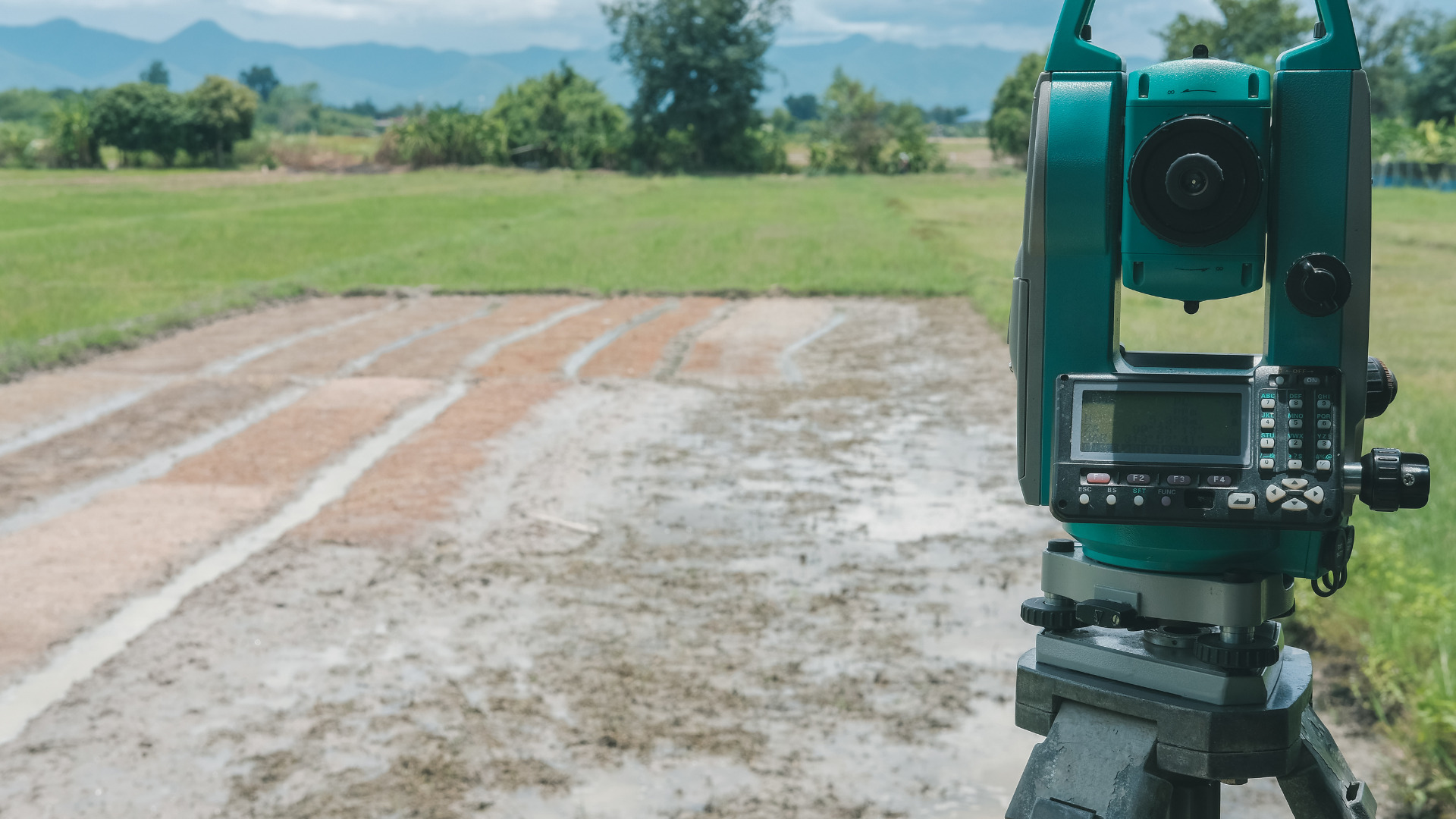
The total station is an advanced instrument and used in surveying and used by surveyors, civil engineers to record topographical data. It is used frequently used instrument. The total station is formed when many other instruments are combined such as theodolite, microprocessor, memory storage device, data recorder, and EDM (Electronic distance measuring device).
This instrument is used for many purposes while surveying such as distance measurement (sloping and horizontal), angle (Horizontal and vertical) measurement, reduced levels, and other related details of the points and stations and all these readings are shown on the screen of the total station.
This is the best device to record data automatically.
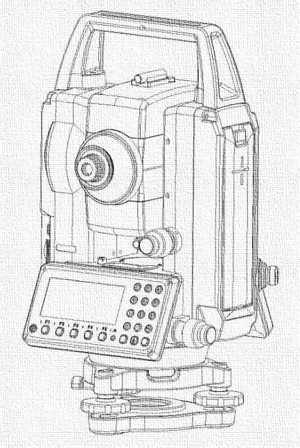
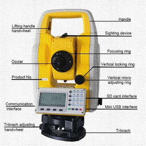
Fig: Total station and its components
Instruments used in total station
- Electronic theodolite
- Microprocessor with memory unit and data collectors
- EDM (Electronic distance measuring device)
- Battery
- Prism and prism pole
- Tripod stand
Detail of each part:
1)Electronic theodolite
It is an optical instrument used to measure angles both horizontal and vertical while using total station with an accuracy of 2-6 seconds. For horizontal angles, any point can be taken as reference and for vertical angles upward direction is taken as reference.
2)The Microprocessor
It is used to measure the horizontal distances and if the certain temperature or any atmospheric pressure is applied automatically corrections are applied. These are used to convert data into digital form.
3)Data collectors
The are used to store and record the observations.

Fig: Data Collector
4)EDM
(Electronic distance measuring device) is used to measure distances with an accuracy of 5-10 mm per km with the help of electromagnetic waves. The range of electronic distance measuring device varies from 2.8-4.2 km.
5)Prism and prism pole
It is used to measure lengths up to 2 km and this limit can be increased up to 7 km by using a triple prism.
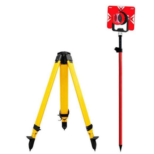
Fig: Prism and prism pole
6)A tripod stand
It is the stand that holds the total station.
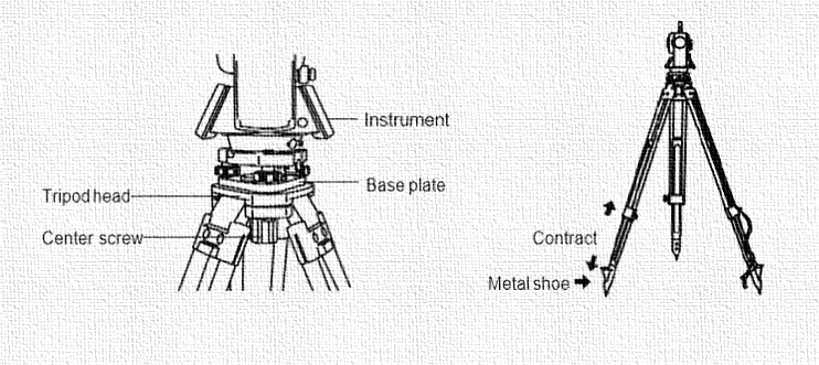
Fig: Tripod stand
Procedure:
Following is the stepwise procedure that is used to operate the total station:
- First step is to Set up the instrument along with the tripod. It includes the fixing of theodolite on a tripod stand.
- Then centering and leveling of the instrument is done. Centering is done by using the centering plate when the vertical axis of theodolite is on the station point Leveling is done with the help of leveling screws and plate level. In the first step of leveling the plate, bubble is adjusted and centered by moving two of the screws in the same direction when it is centered the bubble is aligned parallel to the remaining screw, and by rotating that instrument is leveled and after that leveling is verified electronically.
- In the third step the adjustment of reticle focus and image is done. In focusing, parallax error is removed and this is done by accurately focusing the objective and eyepiece. When the cross-hair and image appear still it means that now the instrument is focused.
- Then the record of all the measurements is taken.
- After taking all the record and readings, data processing takes place. In data, processing microprocessor is used to measure the horizontal distances and if the certain temperature or any atmospheric pressure is applied automatically corrections are applied. These are used to convert data into digital form.
Applications
- Very accurate in coordinates measurement and gives complete data of stations that were found out by traditional surveying like triangulation and trigonometry.
- It contains up-to-date image capture technology that helps in recording and capturing images that are of high quality and this eliminated the need for the field’s revisits.
- We can also save the information and then use it later in computers or laptops for further processing.
- It has replaced manual theodolites.
- It reduces the need for drawing sheets and notes infield as it can save and sketch the data.
Precautions
- Both hands should be used to hold the handle of total station while using it.
- Avoid touching the tripod once it is stable it may cause errors in readings.
- Don’t move the tripod and total station at one time it may cause harm to the instrument.
- Don’t over tighten the screws and clamps.
- Battery must be removed after using the total station.
Advantages and Disadvantages of Total Station:
Advantages:
Following are the advantages of using total station:
- It helps in completing the work quickly and it saves time of work on the field.
- One can go to the office and completes all the calculations in a relaxed environment.
- One more advantage is it can be easily and quickly set up by laser plummet.
- It is very accurate as compared to other surveying instruments.
- Automatic corrections are made on the measurements whenever and wherever needed.
- No need to take notes and hence the chances of errors are negligible.
- Computerization of old maps can be achieved by Total station.
- Data can be saved to the computer and we can use it whenever needed.
- Maps and contours can be easily drawn with the help of the total station.
Disadvantages
Following are the disadvantages of using total station:
- Its cost is the main disadvantage it is expensive than many other traditional instruments that are used in surveying.
- It is very difficult for the surveyor to recheck the work.
- The working conditions of the total station should be checked beforehand by the surveyor before using it.
- Checking for errors or other things during the operation is slightly difficult for the surveyor.
- Skilled and experienced surveyors can operate and handle it because it is an advanced instrument and any mistake while operating can lead to large damage.
- The instrument should be operated in weather where moisture is not an issue because it is an instrument with electronic equipment and parts that may be affected due to moisture.
- To perform work, it is necessary to go to the office and then perform all the necessary calculations that may only be done by using specific software.
Modern total station:
A modern total station is an instrument that can be operated remotely and can be handled by the engineer or surveyor from a distance using a remote.
Now a days robotic total station is used that target the station and point automatically and is very accurate and precise. There is no need of whole surveying team only one person/surveyor can operate it and get the required data.