Table of Contents
Aim:
To run a survey line across an obstacle obstructing both ranging and chaining using chain survey technique.
Equipment and Accessories:
Chain, tape, arrows, ranging rods, pegs, plumb bob, hammer, field-book, pencils, eraser.
Principle:
The main steps involved in chain survey are chaining and taking offsets. During chaining a survey line it may not be always possible to chain line in a straightforward method because of a variety of obstructions to chaining and ranging in the field. The difficulties can be overcome by running perpendicular and parallel lines or by running lines at some suitable angle.
The obstacles may be divided into two classes. Those which do not obstruct the ranging (view) like ponds, rivers etc. fall in the category of obstacles to measurement. The others are those which we cannot see across, i.e., both the chaining and ranging are obstructed, e.g., houses, hay stacks, etc., and are known as obstacles to alignment.
Procedure:
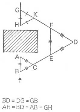
Fig.9 Survey line which is obstructed by a building
It is required to range a survey line which is obstructed by a building. The ranged line as shown in figure proceeds as far as A and can go no farther.
- Mark a point B on the survey line at a convenient distance such that AB forms a base.
- From the base AB set out a point C on the ground such that AB = AC = BC. This results in the equilateral triangle ABC.
- Produce the line BC to set out point D on the ground such that it is clear of the obstacle.
- On the line BD thus formed set out a point E on the ground at a convenient distance such that DE forms a base.
- From the base DE set out a point F on the ground such that DE = EF = DF. This results in the equilateral triangle DEF.
- Produce the line DF to set out point G on the ground such that BD = DG, so that the triangle BDG is also equilateral. (G now lies on the extension of AB. But the direction of the line cannot be established until the third equilateral triangle GHK is set out.)
- On the line DG thus formed set out a point K on the ground at a convenient distance such that GK forms a base.
- From the base GK set out a point H on the ground such that GK = GH = KH. This results in the equilateral triangle GHK.
- Produce HG forward to continue the survey. (HG Produced provides the extension of the survey line AB on the other side of the building)
Observations and Calculations:
- The complete record of the chain survey in addition to all the measurements taken in the field should also include, the date of survey, name of the survey site and the names of the surveyors.
- It is required to draw the plan to a suitable scale. Having chosen a scale obtain the plan dimensions from the field measurements.
Result:
Using the data recorded in the field-book prepare a plan to a suitable scale.