Table of Contents
Aim:
To conduct the chain survey closed traverse around a building and plot the existing building.
Equipment and Accessories:
Chain, Tape, Arrows, Ranging rods, Cross-staff, Pegs, plumb bob, hammer, field-book, pencils, eraser.
Principle:
Traversing is a method of control surveying. Traverse is the framework of survey lines connecting the control points. A series of control points (stations), each one being intervisible with its adjacent stations are chosen. The survey lines joining the control points are called traverse lines. In chain traverse work linear measurements (entire work is done by chain and tape) are taken to establish the lengths and directions of the traverse lines. The offsets necessary to locate the details are taken along the traverse lines in the usual way and recorded in the field-book.
Procedure:
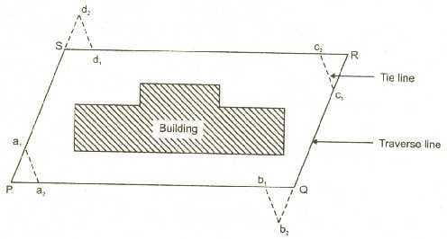
Fig.8 Position of a given building
It is required to plot the position of a given building (for example the building shown in Fig.7 given above).
- Walk over the area to have the general idea about the main features and boundries. Then prepare a neat free-hand sketch in the field book called ‘key plan’ which shows the boundaries, main features, positions of chain lines and survey stations. Draw the north direction on the right hand top corner by an arrow pointing vertically upward.
- With reference to the key plan drawn, mark all the survey stations (for example P, Q, R
and S as shown in figure) on the ground using pegs.
- Range a survey line (say survey line SR) on an any one side of the building.
- Stretch the chain in true alignment along survey line keeping one end of the chain at the starting station. Fix an arrow at the other end of the chain while it is kept laying on the ground.
- Walk along the chain line and take either perpendicular offsets or oblique offsets to the corners of the building and to any other feature that is to be included in plan.
- Record chainages and offsets in the field-book.
- Repeat the process of chaining and offsetting until you reach the end of survey line.
- Complete the survey work along the remaining survey lines.
- At each survey station take tie lines connecting two survey lines and record the measurements in field-book.
Observations and Calculations:
- The complete record of the chain survey in addition to all the measurements taken in the field should also include, the date of survey, name of the survey site and the names of the surveyors.
- It is required to draw the plan to a suitable scale. Having chosen a scale obtain the plan dimensions from the field measurements.
Result:
- Using the data recorded in the field-book prepare a plan of the area surveyed to a suitable scale on an A3 drawing sheet.
- The plan should be oriented in such a way that the north line points more or less upwards.