In this article, we will discuss some basic points that are very important during surveying, because these are the terms that are used in every type of survey. Through this article, we shall learn about these terminologies.
Table of Contents
Angles
Instruments for the measuring angles
This word is derived from the Latin word angulus which means “a corner”. In surveying, the determination of the location of points and orientations of lines mainly depends upon the angles and directions.
- Theodolites
- Total station
- Transits
Requirements to measure an angle
- Reference line
- Value of the angle
- Direction of turning
Units of Angles
In U.S, the Sexagesimal system is mainly used:
- DMS = Degree, Minutes, Seconds
- 1 Revolution = 360o 00’ 00’’
- 1o = 60’
- 1’ = 60’’
In Europe, the centesimal system is used, in which the circumference of the circle is divided into 400 parts known as gon.
- 1 Revolution = 400 grads = 1 Gon
- 1 grad = 0.9o
In Digital computers, Angles are measured in Radians.
- 1 radian = 57.30o
Types of Angles
The Theodolite is an intricate instrument that is mainly used for the accurate measurement of horizontal and vertical angles.
The angles that measure during surveying are classified as follows:
1)Horizontal Angles
An Angle that is made between the two lines on the ground is known as the horizontal angle. Following are some of the types of horizontal angles with their description.
a)Exterior Angles
- It is the measurement of the outside angles of a polygon or a traverse.
- Interior angles + Exterior angles = 360o

b)Interior Angles
- It is the measurement of the inside angles of a polygon or a traverse.
- The sum of all the angles in a polygon must be equal to (n-2) 180o.

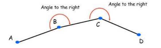
c)Angles to the right
- The angle between the preceding line and the next line of a traverse in a clockwise direction is known as angles to the right.
d)Angles to the left
- The angle between the preceding line and the next line of a traverse in a counter-clockwise direction is known as angles to the left
e)Deflection Angles
- The angle between the extended line and the present one is called the deflection angle.

2)Vertical Angles
- The angle between the horizontal line and the inclined line of sight is known as vertical angle.
- When the angle is above the horizontal line is known as “angle of elevation”.
- When the angle is below the horizontal line is known as “angle of depression”.

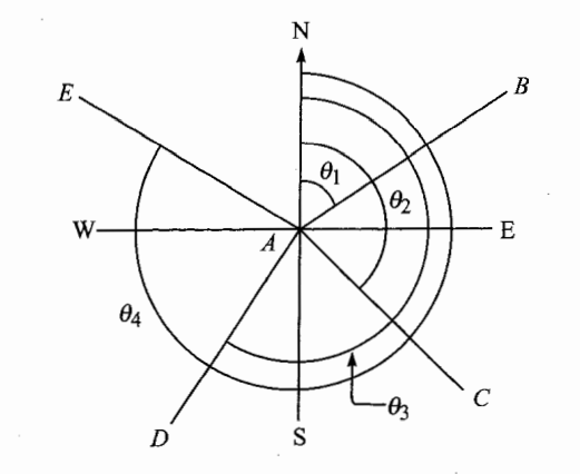
Azimuths
These are the horizontal angles that are measured clockwise from any reference point. North direction is generally taken as a reference point for plane surveying. It ranges from 0o to 360o.
- Every line consists of two Azimuths.
- It can be read directly from the circle easily.
- The measurement of the angle in a forward direction is known as Forwarding Azimuth.
- The measurement of the angle in a backward direction from the reference is known as backward Azimuth.

Meridians
The imaginary arc on the surface of the earth from the North Pole to the South Pole that connects all the locations is called Meridian. Some types of meridians are discussed below:
1)True Meridian
- Any line or plane that passes through the geographical North Pole or the geographical South Pole or any point on the surface of the earth is known as True Meridian.
- It is also known as the geographical meridian.
2)Magnetic Meridian
- When the magnetic needle is suspended freely, unaffected from any magnetic substances then it shows a direction which is known as Magnetic Meridian.
- Then angle between the magnetic meridian and a line is called Magnetic Bearing.
3)Arbitrary Meridian
- To perform the survey of a small area, any convenient direction is assumed as a meridian which is known as Arbitrary Meridian.
- Generally, the start line is taken as an arbitrary meridian.
- The angle between an arbitrary meridian and a line is known as Arbitrary Bearing.
5)Grid Meridian
- For the preparation of a map, some agencies assumed several parallel lines to the true meridian for a particular zone, these lines are termed as Gridlines and the central line is known as Grid Meridian.
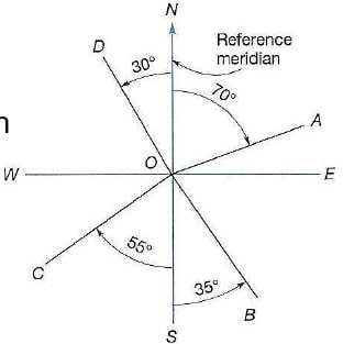
Bearings
It is another system that is used for designating the directions of lines. It is an acute horizontal angle that is measured between the reference point and the line.
- It can be measured from north, south, east, and west.
- The angle reading should be smaller than 90o.
- For example; N 70o E, N 30o W, etc.
Now, we discuss some of the types of bearings that are generally used in surveying.
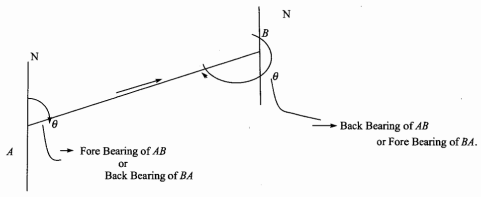
1)Fore and Back Bearing
Every line consists of two bearings, one of them is observed in a forward direction is known as fore bearing while the other is observed in the opposite or backward direction that is known as a back bearing.
2)Whole Circle Bearing
In this type, the magnetic bearing of a line is measured from the North Pole in the clockwise direction towards the line is called Whole Circle Bearing. Its value should be between 0o to 360o.
3)Quadrantal Bearing
In this type, the magnetic bearing can be measured in any quadrant clockwise or counter-clockwise direction. It can be from both North and South Pole towards East or West. Its value should be between 0o to 90o.

4)Reduced Bearing
The conversion of a whole circle bearing into the quadrantal bearing is known as a reduced bearing. It is similar to the quadrantal bearing.
Comparison between Azimuths and Bearings
|
Azimuths |
Bearings |
|
|
|
|
|
|
|
|