Table of Contents
Objective:
The primary objective of this job is to find out the distance between two inaccessible points employing a Prismatic compass.
Apparatus:
- Tripod compass stand
- Prismatic compass
- Ranging rod
- Fiber glass tape
Least Count of the Instrument Used:
Least Count of prismatic compass = 30’ or
Least count of fiber glass tape = 0.01 m
Description of the prismatic compass:
Prismatic compass is a very beneficial instrument that is widely used in the survey for the measurement of survey lines and their bearings. It has the least count of 30 minutes or half degrees A prismatic compass consists of a circular box, about 85 to 100 mm in diameter.
The material with which the box is made is generally or some other non-magnetic material. At the center of the box, there is a hard steel pivot that supports the magnetic needle. The top of the box has a fitted glass disc. The box is covered with a brass lid when the compass is not in use.
The magnetic compass has a graduation from. This graduation is done in the clockwise direction.
Each degree is subdivided into two divisions, each division corresponding to 30’ (the least count of the very instrument).
The prismatic compass has a prism that is used to magnify and invert the reading. Henceforth, during taking a particular measurement, the reading on the compass when viewed from the prism is read in the anti-clockwise direction. The compass also has a prism cover, a sighting slit, and a sighting knob, pushing or lifting pin, and colored glasses.
The colored glasses function to ease the viewing through the prism when the sun obstructs normal vision.
Related Theory:
Inaccessible points
If an obstacle is present in a path AB which obstructs direct measurement between these two points, then these two points are referred to as inaccessible points, and the distance between them is to be determined indirectly.
Types of compasses
In surveying, two types of compasses are used:
- Prismatic compass
- Surveyor’s compass.
Bearing of lines
Bearing is the horizontal angle in direction of a line relative to a given meridian. The bearing of a line gives its direction relative to a given meridian. It can be measured as an angle using any of the
Types of meridians:
In surveying there are three types of meridians:
- True meridian
- Magnetic meridian
- Arbitrary meridians
1)True Meridian
The geographical meridian passing through the true North and South pole is called the true meridian.
2)Magnetic meridian:
Magnetic meridian passes through magnetic North and South. The direction of the magnetic meridian can be confirmed with the help of the magnetic compass.
3)Arbitrary meridian:
Arbitrary meridian is used for rough purposes. Any direction is assumed to be the reference meridian to carry out a small survey.
Whole circle bearing
A system in which the bearing of a line is always measured clockwise from the north point of the reference meridian is called the whole circle bearing system. The angle is thus measured between the reference meridian and the line is called the whole circle bearing of the line. Angles measured with whole circle bearing has a value between 0 to 360 degrees.
Local attraction
Local attraction prevents the needle from pointing to the magnetic north. This is owing to the weather conditions or magnetic objects nearby. In this case, a correction can be applied to enhance the accuracy.
To detect local attraction at a specific place, take the fore and back bearing of each line. If the difference between back and fore bearing comes out to be 180° there is no local attraction present at either station of that particular site.
On the other hand, if the difference of bearings comes out to be other than 180°, the bearing may be rechecked to find out if there is any deviation present due to any surrounding magnetic field of an iron substance near the compass. If the difference is still present, then the local attraction exists at either one or both stations.
Types of variations in magnetic declination
There are four types of magnetic declinations namely:
- Diurnal (daily)
- Annual (yearly)
- Secular (periodic)
- Irregular variations
Procedure:

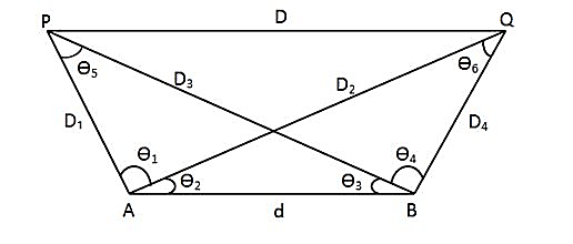
- Let PQ be the required inaccessible distance that is to be measured in the above figure.
- Select AB line parallel to PQ of known length.
- Place prismatic compass at point A and center it and see to it that is parallel to ground surface.
- Measure bearing of line AP, AQ, and AB.
- Now, shift compass to point B and in a similar way measure bearings of lines BP, BQ and BA from observed bearing.
- Calculate the interior angles Ө1, Ө2, Ө3, and Ө4.
Observation & Calculations:
Distance AB = (m)
| Instrument point | Sighted point | Line | Bearing |
| A | P | AP | |
| Q | AQ | ||
| B | AB | ||
| B | P | BP | |
| Q | BQ | ||
| A | BA |
Ө1 =
Ө2 =
Ө3 =
Ө4 =
Ө5 = 180 – (Ө1 + Ө2) − Ө3
Ө6 = 180 – (Ө3 + Ө4) – Ө2
From triangle ABP:
D1 / sin Ө3 = D1 / sin (Ө1 + Ө2) = d / sin Ө5
D2 = (m)
D4 = (m)
From triangle APQ:
PQ2 = AP2 + AQ2 – 2 × AP × AQ × cos Ө1
D = (D12 + D22 – 2 × D1 × D2 cos Ө1) 1/2
OR:
From triangle BPQ:
PQ2 = BP2 + BQ2 – 2 × BP × BQ × cos Ө4
D = (D32 + D42 – 2 × D3 × D4 cos Ө4) 1/2
Results & discussions:
The distance between two inaccessible points has been determined using a prismatic compass.
Precautions:
- All the equipment should be handled with caution and care.
- Safety measures like safety vests, protective footwear, and helmet should be worn by surveyors.
- The center of the prismatic compass should coincide with the station point.
- If the reflection of light with a prismatic lens occurs, use the colored lens of the compass.
- The error due to local attraction, if present, must be eliminated from each observation.